

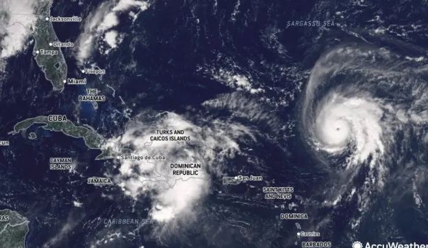
A powerful hurricane known as Humberto has undergone rapid intensification, now packing sustained winds of 145 mph. As of recent updates, it has been classified as a Category 4 storm, placing it among the more destructive classes on the Saffir-Simpson scale. The upgrade signals a marked escalation in threat across the Atlantic region and beyond.
Rising Risks Along the East Coast
Though predicted models currently suggest Humberto will remain offshore, the proximity to the U.S. eastern seaboard raises serious concerns. Officials and meteorologists warn that coastal states—especially areas from Florida up through the mid-Atlantic—should monitor the storm closely. Even without a direct landfall, life-threatening rip currents, large swells, and dangerous surf conditions are expected along several stretches of coastline. Communities in the Bahamas are also in close focus. The storm’s projected track and intensity could impose significant effects there before pushing toward the broader Atlantic. Regions such as the northern Bahamas, the Virgin Islands, and nearby isles are particularly vulnerable to wind, rain, and surf hazards.
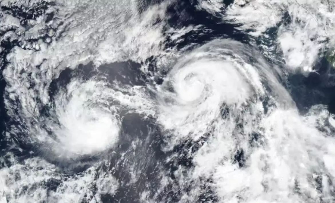
Unusual Interaction: A Second System Looms
Adding complexity to the forecasts is a second developing weather system, referred to as Tropical Depression Nine (or “Invest 94L”). This system is expected to evolve into Tropical Storm Imelda within the next 24–48 hours as it gains strength over warm waters. Its trajectory may lead it to drift northward, potentially moving into regions already under the influence of Humberto. Meteorologists have flagged the possibility of a Fujiwhara effect—a rare interaction in which two storms in close proximity begin to influence each other’s paths. In this scenario, Humberto could deflect Imelda eastward or even absorb it, altering predicted courses and intensities. Such an interaction raises forecast uncertainty and demands vigilance from forecasters.
Forecast Challenges and Uncertainties
While models currently suggest that Humberto might remain offshore, several factors introduce unpredictability. Slight shifts in steering currents, timing, or storm intensity might nudge the path closer to land. The evolving strength of Imelda, and its interaction with Humberto, could also alter both storms’ tracks. Forecasters emphasize that small changes matter, and communities should remain prepared for worst-case scenarios. Coastal areas may begin feeling effects even without a direct hit: increased surf, dangerous tides, and potential flooding in low-lying locales. Rainfall totals are expected to vary, with the heaviest bands likely falling over the ocean and island territories, while the U.S. coast might see more moderate accumulation—though pockets of heavier precipitation remain possible.
Advisory Actions and Preparedness
Authorities in coastal counties are issuing alerts and urging residents to track updates. While no direct landfall warnings have been issued for the U.S. yet, forecasters urge vigilance, especially in areas prone to storm surge or flooding. Emergency services and local governments are preparing for a range of outcomes.
Individuals are strongly advised to:
- Monitor official updates from the National Hurricane Center and local meteorological offices.
- Prepare for sudden changes in conditions—especially along beaches and docks.
- Avoid entering the water or shoreline during storm surge or high surf periods.
- Secure outdoor objects and take flood precautions in vulnerable zones.
Looking Ahead: What to Expect
Over the next several days, forecasters will refine predictions as Humberto moves northward and Imelda develops. The potential of the two systems interacting complicates guidance, making forecasts more fluid than usual. Mariners, coastal communities, and disaster planners alike are watching closely. The path forward hinges on subtle atmospheric shifts—winds, pressure systems, ocean currents, and interstorm dynamics. While the immediate threat to the U.S. remains somewhat uncertain, the intensity of Humberto and the possibility of storm interaction demand that residents from Florida up into the mid-Atlantic stay alert, plan accordingly, and heed official advisories.
")


")


")


