

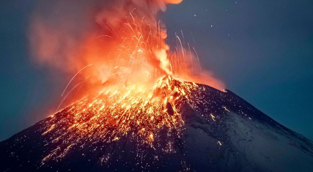
Mount Lewotobi Laki‑Laki, located on Flores Island, Indonesia, erupted at least twice, sending ash and gas clouds into the sky. Find out more in the article below.
Enormous Ash Plumes Trigger Aviation Alerts
Authorities issued a red alert for aviation and food security due to the volume of ash spewed. Indonesia, Japan, and Australia monitored the eruption closely. Japan’s Meteorological Agency also investigated potential tsunami impacts reaching Okinawa that evening. Although no tsunami ultimately occurred, the warning underscored how volcanic ash and pressure waves can destabilize ocean behavior and disrupt air travel.
Destructive Ash Clouds Descend on Villages
The eruption unleashed pyroclastic flows—dense mixtures of hot gas, ash, and rock—racing up to 5 km down the slopes. Villagers reported roofs blanketed under ashes so thick daylight dimmed for nearly 30 minutes. Local warnings emphasized the dangers of ashfall: residents were advised to wear masks and keep pets indoors. The risk of lava-triggered mudflows during upcoming rains was elevated due to loose volcanic debris.
Expanding Exclusion Zones
Indonesia’s Geological Agency declared the volcano at its highest alert level and expanded the exclusion zone from 7 km to potentially up to 8 km, accounting for unpredictable ash and debris trajectories. Seismologists noted that recent eruptions were fueled by crater magma blockages, which built up pressure quietly and then released explosively.
Impact on Air Traffic and Public Safety
The eruptions disrupted air travel as ash clouds drifted into major flight paths. At least 24 international and several domestic flights were canceled or delayed from Bali—though Ngurah Rai Airport stayed open thanks to favorable wind direction. Residents within affected zones were ordered to stay indoors, cover breathing passages, and avoid low‑lying community waterways vulnerable to ash‑induced flash floods.
Comparing with Past Eruptions
While not on the scale of the infamous 1815 Mount Tambora eruption (a VEI‑7 event that triggered global climate anomalies, Lewotobi’s ash columns rival recent historic events—like Grímsvötn’ s 2011 volcanic plume reaching 65,000 ft (≈20 km). These comparisons highlight recurring trends of deadly volcanic hazards in Indonesia, which alone houses over 120 active volcanoes due to its location on the Pacific “Ring of Fire.”
Monitoring, Alerts, and Evacuations
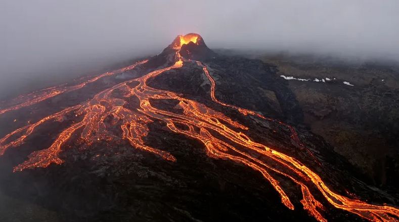
Surveillance tools including seismic sensors, drone footage, and satellite monitoring have been crucial. Videos from drones captured lava inside the crater, confirming internal pressurization. Authorities are reassessing risk zones and preparing for ash‑laden rainfall and lava flow risks. No injuries or fatalities have been reported yet, but officials stress the unpredictable and evolving nature of volcanic activity—known to change rapidly.
Why It Matters: Global Repercussions
Volcanoes like Lewotobi demonstrate how natural events can cascade into broader threats—regional human safety, aviation hazards, environmental damage, and potential coastal impacts from tsunamis. The episode serves as a stark reminder of Indonesia’s volcanic vulnerability—where even ash clouds can reverberate around the globe if large enough, creating disruptions in flight routes, climate patterns, and public health.
Key Takeaway
Mount Lewotobi’s 2025 eruption showcased raw geological power: massive ash columns, flight disruptions, village calamities, and global monitoring responses. It also reaffirmed the importance of early warning systems in Indonesia’s seismically active landscape. As the eruption unfolds, continued vigilance remains essential to protect lives, infrastructure, and air travel.


